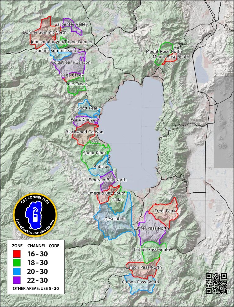
Zones tend to be assigned by drainage or trailhead. They are about 2-3 miles son a side, about the range of an FRS radio and the distance from which people can provide assistance. I designed the zones on the premise “how big of an area do I want to communicate with people. If I am on the Castle Peak approach, do I want to communicate with people on Mt Judah or Tahoe Donner? Zones reusing channels are a minimum of five miles apart. Each zone is assigned one of four colors corresponding to the channel assignment.
- Backcountry zones should be defined on public lands.
- Preferably using natural features (water, ridgelines) or major highways (e.g. CA-89). Boundaries should be easily identifiable in winter conditions (.
- Contiguous.
- Not include ski areas.
- At least one established winter trailhead. Established means that parking is legal, the trailhead is plowed, and there is signage to identify the location. Non-established trailheads include pullouts along a highway or cul-de-sacs in residential streets.
- Zone names should be easily identifiable to users.
- Zones should consider typical usage and not require users to switch channels for most objectives (excluding long traverses). Corollary: Users should be able to use a single channel on a tour.
- Maximum size for a zone should be 3-5 miles. It is not a requirement to communicate from end to end of a zone.
- Zones should have some usage identified (see Strava global heatmap for winter activities). Areas with minimal usage identified may use the regional 5-30 channel.
- Signed trailheads should be established (legal, plowed in the winter, signed).
- Adjacent zones shall be assigned different channels (frequencies). Frequency assignments should not repeat within at least 5 miles.
Considerations
Why would we make a zone smaller?
- Too many people in a zone.
- There is the possibility of communication, but the people are too far away to help.
- There is a natural boundary like I-80 or CA-88.
Why would we make a zone larger?
- Simplicity.
- Typical usage would be within a single zone.
GeoJSON to import to other map programs